Transit Center District Plan Simulations
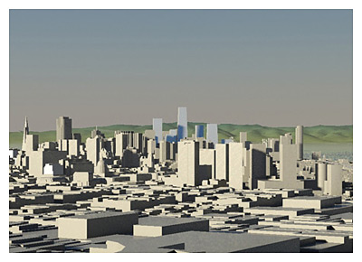
Potential new buildings in the plan area are rendered in shades of blue to differentiate them from existing or already approved buildings. Buildings which are not yet built, but already approved either individually or at a plan-level (e.g. in Rincon Hill, Transbay Redevelopment Area Zone 1, Market/Octavia Plan area) are included and shown at their maximum envelopes in the same way as existing buildings (shades of beige or grey).
The blue "potential" building forms in the simulations do not represent actual building proposals or actual designs, skins, or shapes. They are simple geometric forms intended to show the maximum height and bulk of buildings at the locations being analyzed to assess changes to public views, skyline, and city form.
For each scenario, please refer to the corresponding height maps as shown in the Presentation from April 30, 2008, Part 2a, pages 22-26.
Existing Zoning: All likely development sites are shown at their maximum height and bulk given existing zoning. (Maximum height 550', adjacent to the Transit Center).
Transit Tower 850', 1000', and 1,200': The Transit Tower is shown at the indicated height, and other likely development sites are stepped down from that height accordingly.
Transit Tower 1,200' Plus Developer Proposals: This is a cumulative scenario of the Transit Tower 1,200' Scenario plus all of the proposals currently filed or recently discussed with the Planning Department shown at their approximate maximum height and bulk.
|