|
 City Design Group City Design Group
|
|
|
|
|
|
Transit Center District Plan
In
cooperation with:
Transbay Joint Powers Authority
San Francisco Redevelopment Agency
|
|
ALSO DOWNLOAD:
Historic Preservation Materials
Historic Resources Survey & Context Statement; Transit Center District Plan Historic Preservation Policies and Objectives |
|
 |
|
The
Planning Department has received funding from the San Francisco
County Transportation Authority to draft
a comprehensive plan for the area around the Transbay Terminal,
including mechanisms to direct any increased development value
to help fund the construction
of the Transit Center Program in addition to other public
improvements. This Plan will build on the City’s renowned
1985 Downtown Plan that envisioned the area around the Transbay
Terminal
as the heart of the new downtown. Consistent with the Transbay
Redevelopment
Plan, which focuses mostly on public properties south of
the Transit
Center along Folsom Street, this new effort will focus on
both private properties and properties owned or to be owned by
the
Transbay Joint Powers Authority around the Transit Center
itself.
The
City adopted the Urban Design Element of the General Plan in
1971 and the Downtown Plan in 1985, laying the groundwork for
the downtown San Francisco we know today: a compact, walkable
and dynamic urban center and a dramatic skyline set against the
natural backdrop of the city’s hills. The Downtown Plan
established the growth of the downtown south of Market Street,
with its core of greatest density and greatest heights around
the Transbay Terminal. At the time, the Embarcadero Freeway created
a sharp southern edge to the downtown south of Howard Street.
Since the elevated freeway’s removal, the City has undertaken
several major planning efforts for new downtown neighborhoods
(including Rincon Hill and Transbay) and infrastructure investments
(Transbay Transit Center). These changes, as well as the fact
that significant growth has happened in the 20 years since the
Downtown Plan was adopted, demand a new look at the land uses,
urban form and public realm of the downtown core. This planning
effort is intended to shape the next generation of downtown growth;
it will build on the core cherished principles of city building
at the heart of the Urban Design Element and Downtown Plan.
In
early 2006, a Mayor’s Interagency Working
Group reviewed development assumptions in the existing Transit
Center Program to determine the appropriate planning response to
this facility in the heart of downtown San Francisco and to assess
ways of securing additional funding for the Program. This brief
assessment concludes that raising certain height limits and increasing
development potential in the area would be consistent with the
City’s vision for the Transit Center district. It identifies
a potential for generating additional funds for the Program through
increased tax increment, land sales, and assessments, which would
result from such changes in controls of land use and urban form.
The Working Group also identified the possibility for air-rights
development at the 4th/King
rail station and yards to provide additional
funding for the Program.
Objectives
- Build on the Urban Design Element and
Downtown Plan, analyze modifications to the downtown form
based on new Transbay and Rincon Hill plans and recent development.
- Capitalize
on major transit investment with appropriate land use response
in the downtown core.
- Set guidelines and standards
to build a high-quality public realm and provide public amenities.
- Generate
more revenue for the Transbay Transit Center project and
other public improvements.
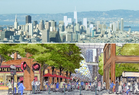
The Project
The
Transit Center District Plan will build on the City’s
renowned 1985 Downtown Plan that envisioned the area around
the Transbay
Terminal
as the heart of the new
downtown. This new effort will analyze land use and urban
form responses to the maturation of the southern side of
downtown
since 1985 and the infrastructure investments now planned.
Following detailed analysis and computer simulation (e.g.
urban form, shadow,
wind, circulation), the study will produce new planning policies
and controls for land use, urban form, building design, and
public realm improvements for private properties as well
as for properties
owned or to be owned by the Transbay Joint Powers Authority
in and around the adopted Transbay Redevelopment Project
Area and
Transbay Terminal. The study will also propose a mechanism
for directing some financial benefit from any increases
in development
opportunity to the construction of the Transit Center Program
and other public amenities and infrastructure in the area.
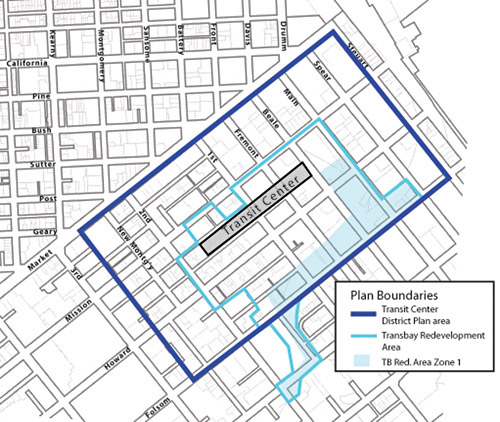
The boundaries of the study area for the Transit Center District Plan are roughtly Market Street on the north, Steuart Street on the east, Folsom Street on the south, and mid-block between 3rd and New Montgomery Streets on the west. The Plan will not affect the adopted land use or development controls for Zone 1 of the Transbay Redevelopment Area.
 Notice
to Project Sponsors in the Transit Center District Plan Area
and Vicinity - PDF Notice
to Project Sponsors in the Transit Center District Plan Area
and Vicinity - PDF
Project Schedule and Public Process
The Planning Department relased a draft Plan document for public review at the Planning Commission on November 19, 2009. A full complement of public discussions and hearings will follow throughout 2010, with the Draft Environmental Impact Report anticipated for publication in mid-2010. Adoption hearings on the Plan are expected in late 2010. Interested members of the public wishing to review the Plan are encouraged to download it. CLICK HERE to download the plan. A CD with the plan can be obtained and printed copies can be purchased at the Planning Department's Planning Information Counter at 1660 Mission Street, 1st Floor. The Plan can also be viewed at the Planning Department offices or the San Francisco Public Library.
During development of the draft plan, the Planning Department held several well-attended public meetings regarding the Plan, each attended by about 200 people or more and primarily held at Golden Gate University.
On May 26, 2009, the Planning Department held its final public workshop prior to completion and publication of the Draft Plan document for formal public review, which anticipated for release in early summer 2009. At this workshop the Department presented the draft proposal for the financial and public benefits program for the Plan. The proposal includes changes to development fees and new additional finanical levies on private projects to raise revenue for public infrastructure improvements in the area, including the Transit Center project and district infrastructure, including streets, open spaces, and sustainable resource district utility systems. Click here to view the powerpoint presentation from that meeting.
On September 17, the Planning Department presented ideas that focussed on aspects of the Plan that will shape the quality of place at the ground level, including building design, ground floor uses, historic resources, and open space, as well as issues of environmental sustainability. Click here to view the powerpoint presentation from that meeting.
On April 30, the Planning Department presentation covered initial findings and proposals regarding citywide and downtown growth, land use, urban form, shadows, historic resources, and the public realm (streets and open spaces). Click here to view the powerpoint presentation from that meeting.
A kickoff meeting was held at the Yerba Buena Center for the Arts on July 25, 2007. Click here to view the presentation from that meeting.
The consultant team working for the Planning Department is led by AECOM (planning, urban design, landscape architecture) and also features Economic & Planning Systems (economic and financial analysis), Nelson/Nygaard (transportation), and Robin Chiang & Co. (urban design, architecture, graphics). Other firms contributing expertise to the effort have included Kelley & VerPlanck (historic preservation) and Seifel Consulting, Inc. (economic and land use analysis).
Stay tuned to this website for announcements of additional workshops, hearings, documents and information, and the Planning Department would always like to hear your comments.
JULY 25 , 2007 |
Public Workshop #1 (Introduction to the planning effort and key objectives) |
APRIL 30, 2008 |
Public Workshop #2 (Land Use/Growth, Draft Urban Form, Historic Preservation, Public Realm Concepts) |
SEPTEMBER 17, 2008 |
Public Workshop #3 (Quality of Place: Urban Design, Open Space, Zoning, Historic Resources, and Sustainability) |
MAY 26, 2009 |
Public Workshop #4 (Public Benefits/Financial Plan and Final Proposals) |
NOVEMBER 19, 2009 |
Publication of Draft Plan for public review |
SEPTEMBER 28, 2011 |
Publication of Draft Environmental Impact Report |
NOVEMBER 28, 2011 |
Comment Period Closes on Draft EIR |
APRIL 19, 2012 |
Informational Hearing at Planning Commission*
We will refresh the Commission about the Plan’s proposals and discuss revisions, updates and refinements to the draft Plan proposals. On this day the packet of key plan adoption materials will be delivered to the Commission and made available to the public, including draft Planning Code, Zoning Map and General Plan amendments. The full packet of materials will be posted here on our project website by close of business on Friday April 20. |
MAY 2, 2012 |
Article 11 Initiation Hearing at Historic Preservation Commission |
MAY 3, 2012 |
Plan Initiation Hearing at Planning Commission*
At this hearing we will continue the informational discussion and ask that the Commission formally initiate the amendments so that an adoption hearing can be held three weeks later. |
MAY 24, 2012 |
Final EIR Certification and Plan Adoption at Planning Commission* |
* Please remember to check the Planning Department’s website for Planning Commission agendas and schedules, as final meeting dates, times, locations and agendas may vary. Planning Commission agendas are typically posted on the Friday before the Commission hearing.
Contact 
Questions,
comments, and suggestions on this planning effort should
be directed to:
Joshua
Switzky, Project Manager
San Francisco Planning Department
1650 Mission Street, Suite 400
San Francisco, CA 94103
Email: Joshua.Switzky@sfgov.org
Telephone: (415) 575-6815 |
Get
Involved!
There will be numerous opportunities for the public to get involved and provide feedback at every stage of plan development and adoption. Please continue to check this website for upcoming events and feedback opportunities.
To
be added to the mailing list to be kept informed of upcoming
workshops and updates, please send an email to Joshua.Switzky@sfgov.org.
Links
and background information:
Draft Plan for Public Review:
Planning Commission Initiation Packet
Informational Presentation to Planning Commission (April 19, 2012) - PDF 11 MB
Initiation Package Table of Contents and Overall Executive Summary
Draft Plan Addendum
General Plan Amendments including Case Report, Draft Resolution, Draft Ordinance, and Draft Sub-Area Plan
Planning Code Amendments including Case Report, Draft Resolution, Draft Planning Code Amendments
Zoning Map Amendments including Case Report, Draft Resolution, and Draft Ordinance
Implementation Package, including Draft Administrative Code Amendments and Draft Program Implementation Document
Environmental Impact Report
Notice of Preparation of Environmental Impact Report (NOP)
for Transit Center District Plan and Transit Tower (July 20, 2008) - PDF
Draft Environmental Impact Report (September 28, 2011)
Historic Preservation
Historic Resources Survey & Context Statement (Adopted July 2008 and February 2012)
Context Statement - PDF 6 MB
Individual Survey (DPR) Forms - PDF 33.5 MB
New Montgomery-Mission-2nd Street District (DPR) Form - PDF 0.5 MB
Transit Center District Plan Historic Preservation Policies and Objectives
Article 11 Categories and Buildings Proposed for Article 10 Designation - PDF
New Montgomery-Mission-2nd Street Conservation District Boundary Changes - PDF
Presentations & Project
Materials:
Public Meeting presentation on Financial Program/Public Benefits. May 26, 2009 - PDF 2 MB
Public Meeting presentation on Quality of Place, Sept. 17, 2008 - PDF 8 MB
Public Meeting presentation on Initial Findings & Proposals, April 30, 2008
Part 1 - PDF 3.5 MB
Part 2a - PDF 8.5 MB
Part 2b - PDF 2 MB
Part 3 - PDF 2.5 MB
Urban Form Simulations
Downtown 2035 Growth/Capacity Analysis - PDF 1.75 MB
Introductory Public Workshop Presentation, July 25, 2007 - PDF 10.5 MB
Informational
Presentation to the Planning Commission, February 1, 2007 - PDF 9.4
MB
Consultant
RFPs & Scope:
EIR
Consultant RFP
RFP
- Transit Center District Plan and Transit Tower EIR (Amended
8-24-07) - PDF
RFP
- Appendix A Part 1 - PDF
RFP
- Appendix A Part 2 - PDF
RFP
- Appendix C - PDF
RFP
- Appendix D - PDF
Questions
& Answers
- Transit Center District Plan and Transit Tower EIR - PDF
RFP
Pre-Bid Presentation August 7, 2007 - PDF 5.7
MB
EIR
Consultant RFP Bidder's Conference Sign-In Sheet - PDF
Planning
Consultant RFP - PDF
Scope
of Work for Downtown Growth Forcasting
and Analysis - Seifel Consulting - PDF
Informal
RFP for Shadow Methodology and Preliminary Assessment - PDF
Background:
Mayor’s
Interagency Transbay Working Group
Final
Report - PDF
Graphic
Presentation ( click on “Item 8” )
Transbay
Joint Powers Authority—Transit Center Program
San
Francisco Redevelopment Agency—Transbay Redevelopment
Project
Rincon
Hill Plan |